AeroTopoL is the only operational GIS-based Mission Planning and Flight Management-System on the market. Beside full GIS functionality, it uses a Wizard to be very user-friendly. AeroTopoL enables many im- and export formats for raster and vector data as well as many coordinate systems. Data of different geodetic datum can be re-projected on the fly.
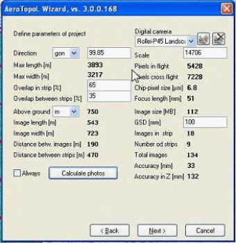
Analysis of overlaps during planning helps with mission planning to predefine best places for GCPs. AeroTopoL supports any frame based analogue or digital camera and calculates the accuracy of the project. With AeroTopoL-DTM the terrain is taken into account in computing adjusted footprints.
AeroTopoL’s oblique option enables planning and navigation for oblique capture missions using set-ups with one or more cameras .
The Scan Option allows planning and navigation with scanning sensor like Lidar.
The virtual avionic instruments enable high precise navigation and keeps overview about the made imagery on a moving map. In real-time AeroTopoL computes the image coverage using terrain-height, flight-altitude, camera-parameters and rotation angles. Analysis on the overlaps give information on a proper coverage.
Comments